Sustainability Nexus Analytics, Informatics, and Data (AID) Programme

INFRASTRUCTURE RESILIENCE
WHY DOES INFRASTRUCTURE RESILIENCE
MATTER?
-
UN’s 2030 agenda for sustainable development recognizes the centrality of infrastructure provision and the interconnectedness of different infrastructure systems and sectors to one another – a nexus of infrastructure. This highlights the challenge planners face in planning, investment, and delivery of infrastructures. In addition, the future is uncertain, and the decisions made with data available now can be useless later on.
-
Infrastructure is a system of facilities required to serve people’s everyday life, such as water and energy supplies, hospital and buildings, schools, and roads.
-
Sustainable planning for infrastructure resilience is key to future economic growth, climate adaptation, society’s productivity, health, and addressing inequality.
-
Aging infrastructures need to be maintained while new ones are planned for.
WHY A NEXUS APPROACH?
The traditional ways for infrastructure planning and retrofitting are based on deterministic approaches: forecast the future and plan ahead. Robust decision-making is a well-established attempt to do the same by identifying plans that perform well under a wide range of plausible future conditions. Recently, adaptive approaches that allow infrastructures to respond to future conditions have been widely used. This includes various methodological development from adaptation pathways to real options analysis. Dynamic adaptive policy pathways, Multistage real option stochastics programming, and decision rules are among them, with applications in transport, energy, water, and flood systems. Technology design and development for air, water, and wastewater treatment are added using data-driven techniques, artificial intelligence, the Internet of Things, and Digital Twin.
The above methods should be revisited for nexus infrastructure interdependence and equitable delivery of services. The simulation platforms should be adjusted to new human and environmental needs and go towards open-source tools for everyone. The visualization interfaces need revision to be more user-friendly. The new era of big data should be accommodated with new smart infrastructure. Automation should be incorporated for flexible, resilient, and adaptive human-centric designs that address climate change and do not neglect the environment. The technologies should be modified to consider the interdependencies and bring on new opportunities for society in terms of safer, greener, and healthier air, water, energy, food, and transport.
AID TOOLS
The tools and methods for infrastructure planning need to:
1. Incorporate the resiliency and nexus between different infrastructure systems and sectors.
2. Include the environment and humans at the center of the planning for a more equitable provision of services.
3. Be flexible to be changed or adapted as new technology, climate conditions, and demographic change occur.
4. Design and implement the aging infrastructure retrofitting with new technological development.
Climate Resilience Evaluation and Awareness Tool (CREAT)
CREAT is a software tool that assists drinking water, and wastewater utility owners and operators in understanding potential climate change threats. The tool also aids in assessing the related risks at their utilities. The software identifies threats based on regional differences in climate change projections; it then assists utilities in designing adaptation plans based on the assessment.

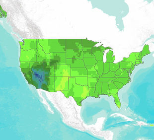
CREAT Climate Scenarios Projection Map
provides easy-to-access scenario-based climate change projections drawn from CREAT. The impacts of a changing climate, including extreme heat and more intense storms, present challenges to water, wastewater, stormwater utilities, and the communities they serve. The first step in climate-related planning is understanding how climate change may affect a utility's ability to maintain and deliver adequate, reliable, and sustainable water supplies and clean water services.
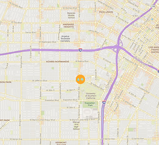
National Stormwater Calculator
EPA’s National Stormwater Calculator is an application that estimates the annual amount of rainwater and runoff from a specific site anywhere in the United States. Estimates are based on local soil conditions, land cover, and historic rainfall records. It is designed to be used by anyone interested in reducing runoff from a property, including site developers, landscape architects, urban planners, and homeowners.
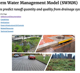
Storm Water Management Model (SWMM)
SWMM is a dynamic hydrology-hydraulic water quality simulation model used for single-event or long-term runoff quantity and quality simulation from primarily urban areas. Users can include any combination of low-impact development (LID)/green infrastructure controls to determine their effectiveness in managing stormwater. SWMM includes a climate adjustment tool (SWMM-CAT), a simple-to-use software that applies monthly climate adjustment factors to precipitation and temperature data.
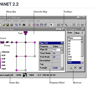
EPANET
EPANET is a software application used worldwide to model water distribution systems. It was developed as a tool for understanding the movement and fate of drinking water constituents within distribution systems and can be used for many different types of applications in distribution systems analysis.
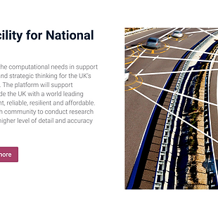
Data & Analytics Facility for National Infrastructure
DAFNI is the National Platform to satisfy the computational needs in support of data analysis, infrastructure research, and strategic thinking for the UK’s long-term planning and investment needs. The platform will support academic research that aims to provide the UK with a world-leading infrastructure system that is more: efficient, reliable, resilient, and affordable. It will achieve this by enabling the research community to conduct research that can generate new insights at a higher level of detail and accuracy than ever before.
Get to Know AID Members
You can consult with the AID group leader or any members for your regional, national, and global datasets, tools, and analytics projects and questions.


Publications

Sustainability Nexus AID: Infrastructure Resilience
This paper highlights the importance of nexus thinking for infrastructure resilience, utilizing analytics, informatics, and data (AID), and presents the Infrastructure Resilience Module, offering tools, data platforms, and capacity building to support integrated, evidence-based decision-making—especially in vulnerable regions of the Global South.