Sustainability Nexus Analytics, Informatics, and Data (AID) Programme

BIOLOGICAL INVASIONS
WHY DOES BIOLOGICAL INVASIONS
MATTER?
-
An invasive species refers to any (often non-native) organism (e.g. plant, animal, or microbe) that is introduced into a new environment, whether intentionally or unintentionally with human assistance, establishes self-perpetuating populations, expands its geographical range, and can cause significant harm to the native ecosystem, economy, or human health.
-
Invasive species have a wide range of negative ecological, economic, and health impacts, e.g. they can:
-
outcompete native fauna and flora for resources such as food, water, and habitat, leading to declines or extinctions of native species
-
change the fire regime which can lead to increased frequency and intensity of wildfires
-
alter hydrology of aquatic ecosystems, which can affect the water quality, sedimentation, and flow patterns
-
Disrupting nutrient cycles, which can have significant impacts on ecosystem productivity and biodiversity
-
reduce forage quality and quantity for livestock or wildlife
-
cause livestock or human health problems by transmitting diseases or causing allergy
-
interfere with recreation (e.g. fishing, jet skiing)
-
-
Biological invasions are considered as one of the four major drivers of ecosystem change along with habitat loss, climate change, and pollution [Link].
-
Biological invasions are widely recognized as the leading driver of biodiversity change in freshwater ecosystems [Link].
-
In Europe, over 10,000 non-native species have been recorded, with approximately 15% of them known to have significant ecological and economic impacts [Link].
-
The economic losses from biological invasions are comparable to those from natural hazards (e.g., $1,208.0 billion for invasive species against $1,139.4 billion for earthquakes accumulated over 1980–2019)[Link].
-
In the United States, the total cost of invasive species between 1960-2020 is estimated at 1.2 to 4.5 trillion USD [Link].
-
Worldwide, the predicted annual cost of invasive species is estimated to vary between $46.8 billion to $162.7 billion in 2017 [Link].
-
In Europe, the cost of control of invasive species and repairing their dames is estimated to exceed €10 billion a year, without considering the cost of major human pathogens or outbreaks of animal diseases [Link]
WHY A NEXUS APPROACH?
The UN Convention on Biological Diversity (CBD) has long recognized the importance of invasive species in disrupting biodiversity by calling contracting parties (Article 8 h, 1992) “as far as possible, and as appropriate, [to] prevent the introduction of, control or eradicate those alien species which threaten ecosystems, habitats or species” [Link]. Even more specifically, in 2010, one of the Aichi targets (Target 9) in the CBD's Strategic Plan for Biodiversity 2011–2020 noted that “by 2020, invasive alien species and pathways are identified and prioritized, priority species are controlled or eradicated, and measures are in place to manage pathways to prevent their introduction and establishment” [Link].
The unprecedented growth of global trade and transportation has facilitated the spread of unwanted biological exchanges, amplifying the urgency for a global and transboundary nexus approach to address the looming issue of invasive species. Despite the significant environmental, health, and socioeconomic impacts of biological invasions, the awareness of their severity remains low. Whereas governments allocate resources to prepare and respond to natural disasters, no analogous measures have been instituted to mitigate invasive species, conceivably as a result of inadequate awareness of the socioeconomic impacts of biological invasions.
Consequently, there is a pressing need for a more systematic and comprehensive accounting of biological invasions to prioritize measures that safeguard the environment and human health and well-being.
Prevention and mitigation of invasive species require a transdisciplinary and global approach entailing collaboration and communication between various fields, including ecology, biology, agriculture, policy-making, sociology and public awareness. This approach should encompass the development and implementation of early warning systems, effective control and eradication measures, and long-term monitoring and management strategies, with a focus on the interconnectedness of the global ecosystem. Engaging with stakeholders, raising public awareness, and investing in research and education are also essential components of this approach to effectively tackle the challenges posed by invasive species.
AID TOOLS
The AID tools available for studying and managing invasive species were classified into seven groups as shown below (note the overlap between the tools across these categories):
-
Mapping and Visualization: These tools allow users to create maps and visualize the spatial distribution of invasive species.
-
Modeling and Prediction: These tools use mathematical and statistical models to predict the potential distribution and spread of invasive species, as well as their impacts on ecosystems and human activities.
-
Risk Assessment: These tools help assess the potential risks posed by invasive species to ecosystems, biodiversity, and human activities. Some of these tools can be used for quarantine purposes.
-
Databases and Data Sources: These resources provide access to a wide range of data on invasive species, including their taxonomy, distribution, ecological impacts, and management strategies.
-
Management and Control: These tools provide information and guidance on the management and control of invasive species, including best practices, regulations, and control methods.
-
Research and Education: These tools provide access to research publications, educational resources, and training materials on invasive species and their management.
-
Citizen Science and Monitoring: These tools engage citizens and other stakeholders in the monitoring and reporting of invasive species, as well as the collection of data on their distribution and impacts.
-
Mapping and Visualization:

Global Biodiversity Information Facility (GBIF):
Global Biodiversity Information Facility is a web-based database that provides open-access data on the world's biodiversity, including invasive species. The database includes maps of invasive species distributions and detailed information on individual species.

European Alien Species Information Network (EASIN)
Species Search and Mapping is a service provided by the European Alien Species Information Network (EASIN). The tool allows users to map the occurrences of species in the EASIN Catalogue from the EASIN Geo Database. Species can be searched by a combination of criteria, mapped by using multiple layer types, and geospatial data filtered by Data Partners and EASIN-Lit information.

Invasive Species Compendium is an online resource developed by CABI
Invasive Species Compendium is an online resource developed by CABI, with support from a consortium of partners, the Invasive Species Compendium is an online, comprehensive encyclopedic reference work covering the recognition, biology, distribution, impact and management of the world’s invasive plants and animals. The Compendium includes various useful features such as images, maps, and diagnostic and decision support tools such as the Horizon Scanning Tool, Pest Risk Analysis Tool, and a new addition - the Invasive Species Discovery Tool.

Integrated Digitized Biocollections (iDigBio)
a web-based database and mapping tool that provides access to digitized biological collections, including specimens of invasive species. The database includes over 130 million specimens from over 1,300 institutions worldwide. It allows users to search and browse through specimens, as well as download data for further analysis. iDigBio also offers tools for data quality control, data integration, and georeferencing of specimen records. The database serves as a valuable resource for invasive species research and management, allowing for the analysis of species distributions, and spread over time.

Atlas of Living Australia (ALA)
Atlas of Living Australia (ALA) is a collaborative, digital, open infrastructure that pulls together Australian biodiversity data from multiple sources, making it accessible and reusable. ALA accommodates over 13,000 datasets and provides mapping tools for exploring distribution of species including many invasive species.

Early Detection & Distribution Mapping System (EDDMapS)
An online mapping system for documenting the distribution of invasive species. It allows users to report sightings of invasive species and generate maps and reports of invasive species distribution. It is designed to help detect new invasive species and prevent their spread.


Pest Tracker
an online mapping tool that provides information about the spread of pests across the United States. The tool enables users to view maps of the distribution of pests and track their movement over time. Pest Tracker uses data from a variety of sources, including state and federal agencies, academic researchers, and citizen scientists. Users can search for specific pests or view maps of all pests in a particular region. The tool also provides information about the biology, ecology, and management of each pest, as well as links to additional resources.

PlantTracker
a mobile app and online platform developed through collaboration between the Environment Agency, Scottish Natural Heritage, the Scottish Environment Protection Agency & Natural Resources Wales, to monitor and map the distribution of non-native and invasive plant species across the country. It allows users to report sightings of plants and record their location using GPS technology, and also includes a photo-upload feature to help verify identification. The data collected through PlantTracker is used to inform conservation management decisions and research, as well as to raise public awareness about the importance of protecting native plant species from invasive threats.

National Exotic Marine and Estuarine Species Information System (NEMESIS)
National Exotic Marine and Estuarine Species Information System (NEMESIS) is a web-based tool for tracking and monitoring the spread of invasive species in marine and estuarine environments. NEMESIS includes detailed information on about 500 species of marine and estuarine of invertebrates and algae introduced to the United States. Each record contains information on taxonomy, distribution, ecology, and impacts, as well as references.


CalWeedMapper
CalWeedMapper is a web-based mapping tool that provides information on the distribution and spread of invasive plant species in California. CalWeedMapper shows landscape-level distribution of invasive plants and suggests management priorities by region. Data obtained from Calflora, the Consortium of California Herbaria, iNaturalist, and expert knowledge collected across the state, organized by 7.5-minute USGS quads.


CLIMEX
CLIMEX is a software for modeling the effects of climate on the geographic distribution of species. It is considered as a mechanistic species distribution model that has been used widely for modeling the potential range limits and distribution of invasive species under current and future climate conditions. However, it is not a free software.


EASIN Notification System (Notsys)
Notsys platform serves as the official notification tool for EU Member States on Invasive Alien Species (IAS). Its primary goal is to enable the timely and comprehensive notification of newly detected IAS of Union concern, and facilitate the implementation of eradication measures.


Risk Identification of Animal and Plant Health Inspection Service (APHIS)
Risk Identification of Animal and Plant Health Inspection Service (APHIS) analyzes present, future, and emerging threats to animal health to estimate the likelihood of a damaging event, and to determine potential pathways of introduction and spread.

Pest Risk Analysis
Pest Risk Analysis framework has been developed by International Standards for Phytosanitary Measures (ISPMs) of Food and Agriculture Organization of the United Nations (FAO).

Environmental Impact Classification for Alien Taxa (EICAT)
Environmental Impact Classification for Alien Taxa (EICAT) is a global standard established by the International Union for Conservation of Nature (IUCN) to assess the degree of harm caused by non-native animals, fungi, and plants that exist outside their natural habitats. This system provides a framework to evaluate the severity of environmental impacts resulting from these invasive species and serves as a tool for conservation efforts worldwide.


Weed Risk Assessment (WRA)
Weed Risk Assessment (WRA) system, developed in Australia, is a question-based assessment of the weed potential of plants proposed for import. The assessment is based on the plant's biological and ecological traits, as well as its potential for establishment and spread in a new area.


Global Biodiversity Information Facility (GBIF):
Global Biodiversity Information Facility is a web-based database that provides open-access data on the world's biodiversity, including invasive species. The database includes maps of invasive species distributions and detailed information on individual species.

European Alien Species Information Network (EASIN)
An online platform that provides information on invasive alien species (IAS) in Europe. EASIN is a comprehensive database that includes information on the taxonomy, distribution, and impact of IAS in Europe. The platform includes tools for mapping and visualizing IAS distribution, as well as a reporting system for citizen scientists to contribute observations of invasive species. EASIN also provides access to a wide range of datasets, such as distribution maps, species fact sheets, and risk assessments. The platform is intended to support policy-makers, researchers, and the general public in managing and preventing the spread of IAS in Europe.

Integrated Digitized Biocollections (iDigBio)
Integrated Digitized Biocollections (iDigBio): Funded by the National Science Foundation, iDigBio is a web-based database and mapping tool that provides access to digitized biological collections, including specimens of invasive species. The database includes over 130 million specimens from over 1,300 institutions worldwide. It allows users to search and browse through specimens, as well as download data for further analysis. iDigBio also offers tools for data quality control, data integration, and georeferencing of specimen records. The database serves as a valuable resource for invasive species research and management, allowing for the analysis of species distributions, and spread over time.

Atlas of Living Australia (ALA)
Atlas of Living Australia (ALA) is a collaborative, digital, open infrastructure that pulls together Australian biodiversity data from multiple sources, making it accessible and reusable. ALA accommodates over 13,000 datasets and provides mapping tools for exploring distribution of species including many invasive species.


Global Registry of Introduced and Invasive Species (GRIIS)
Global Registry of Introduced and Invasive Species (GRIIS) is a web-based database that provides information on invasive species around the world. GRIIS is a collation of data across 196 individual country checklists of alien species, along with a designation of those species with evidence of impact at a country level.

CABI-Invasive Species Compendium
CABI-Invasive Species Compendium: Developed by CABI, with support from a consortium of partners, The Invasive Species Compendium is an online, comprehensive encyclopedic reference work covering recognition, biology, distribution, impact and management of the world’s invasive plants and animals. CABI Compendium includes images, maps, and diagnostic and decision support tools such as The Horizon Scanning Tool, Pest Risk Analysis Tool, and a new addition - the Invasive Species Discovery Tool.

Invasive Plant Atlas of the United States
Invasive Plant Atlas of the United States: Provides list of non-native invasive plant species impacting natural areas, excluding agricultural and other heavily developed and managed lands. Four main components are species information, images, distribution maps, and early detection reporting procedures.


Invasive Species South Africa
Invasive Species South Africa provides information about invasive species (both plants and animals) in South Africa. The site includes a database of invasive species with details on their ecology, distribution, and impacts, as well as a range of tools and resources for managing and controlling invasive species.


Invasoras.pt
Invasoras.pt is a platform for information and citizen science on invasive plants in Portugal. It offers a list of invasive species along with detailed fact sheets to help the public identify them and provides information on legislation governing these species. The platform collaborates with Biodiversity4All/iNaturalist to crowdsource data on invasive plant sightings, allowing citizens to submit observations via mobile app or website to assist in mapping these species. It also outlines various control methods, including physical, chemical, and biological options, with guidance on selecting the most effective approach for each situation. This site serves as a vital resource for educational outreach and citizen involvement in managing invasive species throughout Portugal.


National Invasive Species Council (NISC)

National Invasive Species Information Center (NISIC)
National Invasive Species Information Center (NISIC) was established in 2005 within the U.S. Department of Agriculture (USDA's) to meet the information needs of users, including the National Invasive Species Council (Council or NISC). The council has developed a National Invasive Species Management Plan to guide efforts to prevent, control, and eradicate invasive species across the United States.

PlantwisePlus Knowledge Bank
Plantwise Knowledge Bank is an open access gateway to practical plant health information and services – from diagnostic and management advice to maps of pest locations and customized alerts on pest news. It provides information on the identification, prevention, and management of invasive species affecting plants. Users can browse pest management resources by country, including pesticide lists, diagnostic support and guidelines for writing extension materials.

Australian Government Department of Agriculture, Water and the Environment
Australian Government Department of Agriculture, Water and the Environment has a dedicated website on pests, diseases, and weeds that provides information on invasive species and their management. The website includes resources on identification, control, and prevention, as well as guidelines for biosecurity and quarantine.


International Plant Protection Convention (IPPC)
The IPPC is an international treaty aimed at preventing the spread of pests and diseases that can damage crops and natural ecosystems. The IPPC provides standards and guidelines for the management of invasive species, including phytosanitary measures for the international trade of plants and plant products.


National Invasive Species Awareness Week (NISAW)
National Invasive Species Awareness Week (NISAW) is an international event to raise awareness about invasive species, the threat that they pose, and what can be done to prevent their spread. NAISMA hosts educational webinars on priority invasive species issues the week of NISAW and the 3rd Wednesday of each month.


iNaturalist
iNaturalist is a citizen science project and online social network that allows users to record and share observations of biodiversity around the world. Users can upload photos and observations of plants and animals, which are then reviewed by a community of experts for identification. The data collected on iNaturalist can be used to understand species distributions, biodiversity, and track the spread of invasive species. The platform also includes features such as mapping and journaling, and encourages collaboration and engagement among its users.

pl@ntNet
pl@ntNet, is a Mobile/Web application with over 35,000 plant species and ~15 million images, where users can identify plants, including invasive species, by taking or uploading photos of plants they encounter. The app also allows users to contribute to citizen science by uploading their observations and contributing to a database of plant occurrences.

Early Detection & Distribution Mapping System (EDDMapS)
Early Detection & Distribution Mapping System (EDDMapS): An online mapping system for documenting the distribution of invasive species. It allows users to report sightings of invasive species and generate maps and reports of invasive species distribution. It is designed to help detect new invasive species and prevent their spread.
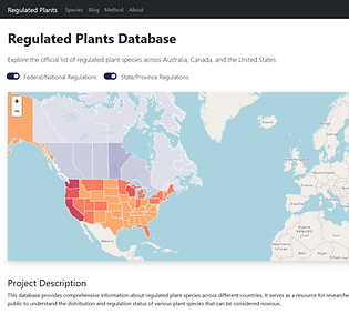
Regulated Plants Database
Hosted by UNU-INWEH, the Regulated Plants Database is an interdisciplinary initiative that unites expertise in botany, data science, geospatial analytics, and policy. Its mission is to deliver a continually updated, freely accessible repository of regulated invasive plants worldwide. This database provides comprehensive information about regulated plant species across different countries. It serves as a resource for researchers, agricultural professionals, and the public to understand the distribution and regulation status of various plant species that can be considered noxious.
2. Modeling and Prediction Tools:
3. Risk Assessment Tools:
4. Databases and Data Sources tools:
5. Management and Control Tools:
6. Research and Education Tools:
7. Citizen Science and Monitoring Tools:
Get to Know AID Members
You can consult with the AID group leader or any members for your regional, national, and global datasets, tools, and analytics projects and questions.


Publications

Sustainability Nexus AID: Biological Invasions
This paper underscores the need for a transdisciplinary approach to addressing biological invasions. It introduces the AID Biological Invasions Module—comprising 56 tools across six categories—and highlights their role in supporting science-informed policy, international cooperation, and proactive strategies aligned with the Sustainable Development Goals (SDGs).